

guy
-
Posts
2,366 -
Joined
-
Last visited
-
Days Won
135
Content Type
Profiles
Forums
Static Pages
News
Blogs
Gallery
Events
Downloads
Posts posted by guy
-
-
Very interesting. The fact that none of the fragments were curved, however, makes me think a column was unlikely.
On 1/15/2024 at 8:43 AM, caesar novus said:I thought until recently it was affixed to an external brick wall, but that was probably from a Mussolini era re-imagining. Whether horizontal or vertical, it could have had elevated viewing platforms, like for Trajan's Column or a mosaic floor in Anacapri:

-

An extensive water system has been uncovered in the ancient Byzantine city of Dara (in the Mardin Province of Turkey).
Dara was an important fortress city on the border with the Sassanid Empire, playing an important role in the Byzantine-Sassanid conflicts of the sixth and seventh century AD.
https://www.dailysabah.com/turkiye/1500-year-old-roman-era-well-unearthed-in-turkiyes-mardin/news
 Location of the ancient city of Dara
This short video shows some of the wonderful remains of Dara: -
 Coin of Aurelian (AD 274)) who, during his reign, elevated Sol Invictus to the highest position among the gods.
Here is an excellent video on coins with Sol Invictus.
Below are previous threads on Sol invictus:
-

Archaeologists working at the ancient city of Tarquinia, north of Rome, have unearthed an ancient Roman necropolis containing 67 skeletons buried in 57 tombs. These tombs have been dated from the second to fourth century AD. The skeletons were dressed in ornate jewelry and leather shoes, evidence of a necropolis for elite Romans.

https://www.ancientpages.com/2024/01/09/roman-necropolis-dressed-skeletons/amp/ -

Archaeologists have uncovered the Roman port Miseno (Misenum) at the Bay of Naples. It was here that Pliny the Elder was the praefect in charge of the naval fleet that later embarked on its ill-fated rescue mission to Pompeii in AD 79.
https://www.heritagedaily.com/2024/01/roman-villa-complex-found-at-miseno/150244
-

A hoard of Roman goods known as the Knaresborough hoard was discovered in 1864. Most of these thirty items are now on display at the Yorkshire museum. Until recently, no close analysis of these items had been made.
 Quote
QuoteThe research by Jessica, and colleagues at Newcastle University, suggests that the hoard was probably discovered in a boggy area near Farnham, in the Vale of Mowbray, approximately two miles north of Knaresborough. During the Roman period, two important Roman roads ran through the Vale: Cade’s Road, which ran north-south on the eastern side, and Dere Street to the west, which was a significant route providing a connection to York and Hadrian’s Wall. Because of these connections, there were a number of wealthy Roman villas in the area and it is thought that the items in the collection may have come from one of these, or an affluent townhouse or settlement close by.
The Knaresborough Hoard is the only known example of a late Roman hoard of this type to be recovered from a bog or marsh in Britain.
https://www.ncl.ac.uk/press/articles/latest/2024/01/knaresboroughhoard/

Location of Knaresborough discovery
-

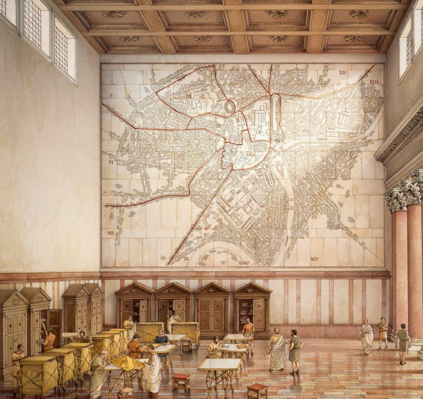
The Severan marble map of Rome known as the Forma Urbis Romae will finally be on display (see video below):

QuoteThe Forma Urbis Romae, or map of the city of Rome, was a massive plan of the layout of the city under the emperor Septimius Severus (r. A.D. 193–211). Although only a small portion of the plan survives, scholars are relatively certain it illustrated most of the city.
Here is a previous discussion involving this wonderful ancient relic:
-

Calls have been made to halt unsupervised excavations near the Northern English villa of Marske-by-the-Sea after remains of a potential Roman settlement have been discovered in the area.
A significant Roman community in the area could add to the understanding of the Roman presence in Northern England.
https://www.bbc.com/news/uk-england-tees-67935267
 The location of the Northern English villa of Marske-by-the-Sea
-

A lead sling bullet has been discovered. It is thought to bear Julius Caesar’s name “CAES” along with “IPSCA,” a nearby town that supported Caesar and supplied him with both weapons and men during Caesar’s Civil War against the Optimates (49-45 BCE).
The bullet was found near modern day Montilla in Andalusia, Spain. This finding supports the belief that the climactic Battle of Munda (17 March 45 BCE) was fought nearby. At the battle Caesar decisively defeated a larger force led by former Caesar general and ally Titus Labienus and Gnaeus Pompeius (eldest son of Pompey).
 Location of Montilla, possibly the site of the Battle of Munda, where the bullet was discovered.
https://youtu.be/_Z2cJlbkDmE?si=jwTuzSiDD2UisWyG
https://www.thehistoryblog.com/archives/69175
https://www.heritagedaily.com/2024/01/julius-caesar-inscribed-sling-bullet-found-in-montilla/150138
https://en.m.wikipedia.org/wiki/Battle_of_Munda
-
6 hours ago, guidoLaMoto said:
Question: Constantine's mother, Helen (to become St Helen), was a big influence in finding and establishing several sites as holy places in Christianity-- did she become a Christain before or after her son's famous "In hoc signum.." dream?
Interesting question. The sources vary. By some, Helena is thought to have been a Christian at birth (AD 246/248); by others, only after Constantine become emperor (AD 306).
According to church historian Eusebius of Caesarea (d. AD 339), Helena’s conversion followed Constantine becoming emperor. If that were true, Helena would have been approaching 60 at the time.
I would need to do more research on that question.
-
Professor Roberto Trizio explores the sanctioned coexistence of the Imperial Cult and Christianity that is exemplified by this discovery. (This video is in Italian so most of us will need to enable the YouTube autotranslate function.)
-
The short video above is a really simple description of how the ancient Greek Eratosthenes from Cyrene calculated the circumference of the planet Earth around 240 BCE. (This clip is taken from a longer segment below.)
QuoteEratosthenes had heard from travelers about a well in Syene (now Aswan, Egypt) with an interesting property: at noon on the summer solstice, which occurs about June 21 every year, the sun illuminated the entire bottom of this well, without casting any shadows, indicating that the sun was directly overhead. Eratosthenes then measured the angle of a shadow cast by a stick at noon on the summer solstice in Alexandria, and found it made an angle of about 7.2 degrees, or about 1/50 of a complete circle.
He realized that if he knew the distance from Alexandria to Syene, he could easily calculate the circumference of Earth. But in those days it was extremely difficult to determine distance with any accuracy. Some distances between cities were measured by the time it took a camel caravan to travel from one city to the other. But camels have a tendency to wander and to walk at varying speeds. So Eratosthenes hired bematists, professional surveyors trained to walk with equal length steps. They found that Syene lies about 5000 stadia from Alexandria.
Eratosthenes then used this to calculate the circumference of the Earth to be about 250,000 stadia. Modern scholars disagree about the length of the stadium used by Eratosthenes. Values between 500 and about 600 feet have been suggested, putting Eratosthenes’ calculated circumference between about 24,000 miles and about 29,000 miles. The Earth is now known to measure about 24,900 miles around the equator, slightly less around the poles.
interesting to note that Eratosthenes was from Cyrene, noted for its cultivation of the near-mythical plant Silphium (a frequent topic in the past found in the post below).
https://www.aps.org/publications/apsnews/200606/history.cfm
-

A Roman temple dedicated to the Imperial Cult dating from the Christian 4th century AD has been discovered in Spello, Italy.
Professor Bonin had directed underground imaging that suggested the structure existed underneath a parking lot.This temple reflects the persistence of pagan traditions along with the arrival of Christianity.
QuoteBoin, an expert in ancient Roman and its religious transitions, had been digging in the town of Spello, the famous medieval hilltop city about 20 minutes from Assisi and 2.5 hours north of Rome. Boin selected the town based on a rescript of a 4th-century letter from Emperor Constantine to the townspeople regarding a religious holiday.
This rescript, which was discovered in the 18th century, allowed the people of Spello to celebrate a religious festival in their hometown rather than travel a great distance to another festival. However, in order to do so, the town was told it must erect a temple to Constantine's divine ancestors, the Flavian family, and worship them, showcasing how multicultural Roman society was at the time.
https://phys.org/news/2024-01-cult-mentality-professor-monumental-discovery.amp
-

Before people learned to extract iron from ore during the Iron Age, meteorites were the only source of the metal. This iron Bronze-age arrowhead found in Mörigen, Switzerland was not surprisingly crafted from a meteorite. It dates to 900-800 BCE.
After closer analysis, however, the meteorite iron source was determined to be most likely from a meteorite that fell in distant Estonia. This distance of 1600 km (almost 1000 miles) from the Baltic area may reflect the extensive trade in Bronze Age Europe.
In 2021, a team of scientists from the institution began studying the relic using noninvasive methods—including electron microscopy, X-ray tomography, and gamma spectrometry—to prevent any damage.
While the researchers initially suspected the material to have come from the Twannberg meteorite, which hit a barley field in [nearby] Twann about 170,000 years ago, the arrowhead’s metal content led them instead to the Kaalijarv meteorite.
The Kaalijarv meteorite, also known as Kaali, landed in the region of Estonia during the Nordic Bronze Age (c. 1700–500 B.C.E.).
https://news.artnet.com/art-world/bronze-age-arrowhead-made-from-meteorite-2345756/amp-page
https://www.sciencedirect.com/science/article/pii/S0305440323001073?via%3Dihub#sec4
-

Naxian sphinxes depict a winged lion with a female face. One example from the third century AD was uncovered in the Roman provincial town of Potaissa in ancient Dacia, located in present-day Romania. The bronze sphinx was stolen in the nineteenth century and never has been recovered. Based on a surviving drawing, however, the sphinx inscription has finally been translated.
Note that the poem needs to be read right to left. A "dactyl" in poetry is a poetic foot (rhythmic unit) consisting of a stressed syllable followed by two unstressed syllables, but in this inscription which is read right to left, the patten is the opposite.
QuoteAn examination of sketches depicting the sphinx revealed that the inscription constitutes a metric poem composed in dactylic hexameter. This intricate poetic meter originated from ancient Greek verses and was subsequently embraced by Latin literature. Dactylic hexameter employs a recurring rhythmic structure of six metric feet per line, accentuating certain syllables over others.
According to the study, the poem is written in a proto-Hungarian language and welcomes visitors approaching the sphinx: Íme imádd: itt híres oroszlán (“Lo, behold, worship: here is the holy lion”).
https://arkeonews.net/mysterious-inscription-on-ancient-dacia-sphinx-is-deciphered/
https://www.heritagedaily.com/2024/01/inscription-on-naxian-style-sphinx-deciphered/150132
QuoteThis paper gives a translation of an inscription around the base of a bronze sphinx statue from the 3rd century Roman Province of Dacia. The bronze sphinx statue has several striking parallels with the famous Sphinx of the Naxians from 560 BCE, which is now located in the Archaeological Museum of Delphi. Presumably, the sphinx cult also spread to Dacia from Naxos. The inscription is identified as having been written using an archaic Greek alphabet. However, the Greek alphabet phonetic values render a text that is non-sensical in the Greek language. Therefore, the meaning of the inscription has puzzled scholars since the artifact’s discovery in the early 19th century. The scribe probably intended to express something in a language other than Greek using an archaic Greek alphabet. The archaic Greek alphabet phonetic values record a short rhythmic poem in the Proto-Hungarian language. The inscription is unusual in that it contains some archaic letters that are mirrored and need to be read from right to left.
-

A small hoard or cache of ten coins dating from the reign of Byzantine Emperor Constans II (AD 641-668) have been discovered in the ancient city of Hadrianopolis in the modern day Karabük’s Eskipazar district in Turkey.
http://www.thehistoryblog.com/archives/69169
https://arkeonews.net/1400-year-old-coins-found-in-a-piggy-bank-in-ancient-city-of-hadrianopolis/#


-
23 hours ago, Gordopolis said:
I am interested in the Venetian Empire/Republic history too, but I am very much a novice in that period. Is the Maritime Musuem the same as the Arsenale?
What a wonderful trip planned. Despite traveling to Italy a few times to visit relatives, I’ve never been to Venice. Looking at the map, the two places are very close, but are distinct sites. Looking at web sites, only the North Arsenal is regularly open. The Southern Arsenal is open only during the biannual art festival.

From the picture, one can see the Arsenal and the maritime museum (Museo Storico Navale) are extremely close.
Sounds fun. Post pictures.
https://en.m.wikipedia.org/wiki/Museo_Storico_Navale
-
5 hours ago, guidoLaMoto said:
Those authors seem to forget that tree rings reflect mostly the availability of water, with temps being irregularly & innaccurately correlated with ring diameter.
Thank you for reading my post. You made some interesting and very credible points.I would say, however, that the above description of the cause of the ring width is possibly a little too simplistic. I like the multifactorial explanation below better. It seems to me that ring width is a useful tool to assess not only precipitation, but it is also useful to analyze a large array of local climate conditions.
QuoteThe mean width of a ring in any one tree is a function of many variables, including the tree species, tree age, availability of stored food within the tree and of important nutrients in the soil, and a whole complex of climatic factors (sunshine, precipitation, temperature, wind speed, humidity, and their distribution through the year). The problem facing dendroclimatologists is to extract whatever climatic signal is available in the tree ring data and to distinguish this signal from the background noise.
https://www.sciencedirect.com/science/article/abs/pii/B9780123869135000132
-
In this short video, Max Miller actually cooks with his garum concoction:
-

A head of Bacchus that dates to the Ancient Greek era has been discovered in the water near the Ancient Greek city of Cyrene in modern day Libya. The artifact may have been uncovered as a result of a storm in September.


The city of Cyrene was well know for its export of the coveted medicinal plant silphium (see post below):
-
This the latest improved version of this video view of Ancient Rome. This version has more colorized buildings:
-
There have been previous posts about the Carnyx, the frightening Celtic instrument (see below). Here’s an excellent review of the Carnyx and its role in Celtic history.
-
 Today (late December), the morning sky outside my window is either an auspicious or an ominous sign of what the new year (2024) will bring. Let’s hope the new year will bring all good health and fortune. I wonder what our local augur would say.
-

A Roman-era man in Cambridgeshire has been shown by DNA analysis to have been born outside the Roman Empire and he is of Sarmatian descent, living around modern-day southern Russia and Ukraine. The Sarmatians were a nomadic horse-riding peoples originating in the Eurasian Steppe.
By analyzing his teeth, researches also learned about his diet.
 Quote
QuoteThe man’s remains were found close to the village of Offord Cluny, near Huntingdon, in 2017. He lived around AD 126-228.
Professor Janet Montgomery of Durham University said: “Until the age of five or six, he lived in an arid location in the east of continental Europe.
“His diet at this age contained a lot of C4 crops, such as millet and sorghum, which are not native to Europe.
“As he grew up, he migrated west, and these plants disappeared from his diet.
In 175 AD Emperor Marcus Aurelius defeated a Sarmatian army on the northeastern border of the Roman Empire and incorporated their cavalry into his legions.
According to the historian Cassius Dio, Marcus Aurelius sent around 5,500 of these Sarmatians to join the Roman legions in Britain.
https://www.huntspost.co.uk/news/23997908.a14-cambridgeshire-mans-remains-offers-insight-romans/


Roman Chedworth Villa active at AD 480
in Archaeological News: Britain and Roman-Britain
Posted · Edited by guy
There have been previous threads on the Chedworth Roman Villa before. There was some suggestion that the structure had been created and in active use in the fifth century AD (see posts below). More precise radiocarbon dating of charcoal samples have shown that “the mosaic was determined to have a median construction date most likely set in 480s AD.”
This late date of construction confirms the belief that there was an active and thriving RomanoBritish community despite Rome’s official withdrawal from Britain around AD 410.
https://bnnbreaking.com/world/uk/chedworth-roman-villa-discovery-challenges-conventional-understanding-of-post-roman-britain/